Baltimore, Maryland & Washington, DC Area and 50 similar items
Free Shipping
Baltimore, Maryland & Washington, DC Area Wall Map
$266.31
Sign up and get $15.00 bCredits free to use at checkout and another $5.00 bCredits when you make your first purchase. More info
Share & earn! Sign in, share this or any listing, and you’ll get commission when it sells.
Learn more
View full item details »

Shipping options
Estimated to arrive by Thu, Oct 30th.
Details
FREE via UPS Ground (1 to 5 business days) to United States
Return policy
Replacement product available within 30 days
Details
Purchase protection
Payment options
PayPal accepted
PayPal Credit accepted
Venmo accepted
PayPal, MasterCard, Visa, Discover, and American Express accepted
Maestro accepted
Amazon Pay accepted
Nuvei accepted
View full item details »
Shipping options
Estimated to arrive by Thu, Oct 30th.
Details
FREE via UPS Ground (1 to 5 business days) to United States
Return policy
Replacement product available within 30 days
Details
Purchase protection
Payment options
PayPal accepted
PayPal Credit accepted
Venmo accepted
PayPal, MasterCard, Visa, Discover, and American Express accepted
Maestro accepted
Amazon Pay accepted
Nuvei accepted
Item traits
| Category: | |
|---|---|
| Quantity Available: |
Only one in stock, order soon |
| Condition: |
New |
| Country/Region of Manufacture: |
United States |
Listing details
| Seller policies: | |
|---|---|
| Posted for sale: |
More than a week ago |
| Item number: |
814739191 |
Item description
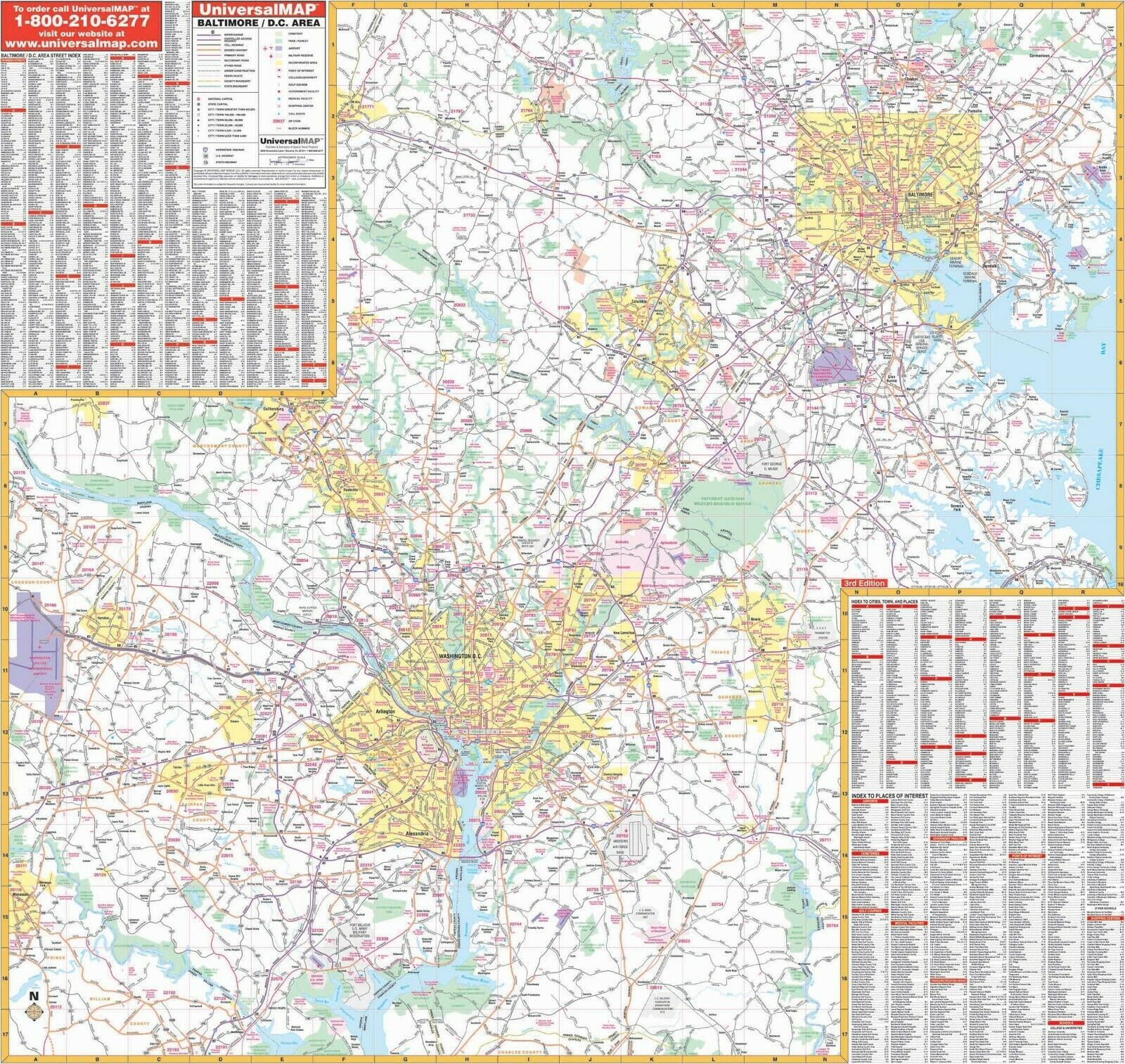
Baltimore, Maryland Washington, DC Area Wall Map
This 3rd edition Wall Map covers Baltimore, MD and the DC area. Measures 56? x 54? (4?8? W x 4?6? H) at a scale of 1?=4,950 feet. Printed in color with a markable/washable-laminated surface.
Streets are indexed on the face of the map.
Area of coverage: North: to Lock Raven Reservoir, Kingsville, Pot Spring, and Louisville; South: Lower Marlboro, Mattawoman, Strawberry Hills, Dale City; East: Chesapeake Bay, Martin State Airport, Upper Falls; West: Mt. Airy, Dulles International Airport, Manassas.
Features indices of major streets, cities, towns, and points of interest. Details interstate/state/federal highways, county roads, shopping centers, military installations, airports, water features, parks and national forests, hospitals, recreation areas, colleges, and points of interest.
|
Why are we showing these items?
Search Results
Map, transportation"map" Category "Transportation"
|


 - $2.95")
 - $3.75")

 - $3.70")


-
Refine your browsing experience
We can show you more items that are exactly like the original item, or we can show you items that are similar in spirit. By default we show you a mix.


This item has been added to your cart
 Baltimore, Maryland & Washington, DC Area Wall Map added to cart.
Only one available in stock
Baltimore, Maryland & Washington, DC Area Wall Map added to cart.
Only one available in stock
View Cart or continue shopping.
 Please wait while we finish adding this item to your cart.
Get an item reminder
We'll email you a link to your item now and follow up with a single reminder (if you'd like one). That's it! No spam, no hassle.
Already have an account?
Log in and add this item to your wish list.