HISTORIX Vintage 1876 Arizona Territory Map and 50 similar items


Free Shipping
HISTORIX Vintage 1876 Arizona Territory Map - 18x24 Inch Vintage Arizona Map - O
$39.99 - $54.99
View full item details »

Shipping options
Seller handling time is 1 business day Details
FREE via to United States
Return policy
Full refund available for DOAs
Details
Purchase protection
Payment options
PayPal accepted
PayPal Credit accepted
Venmo accepted
PayPal, MasterCard, Visa, Discover, and American Express accepted
Maestro accepted
Amazon Pay accepted
Nuvei accepted
View full item details »
Shipping options
Seller handling time is 1 business day Details
FREE via to United States
Return policy
Full refund available for DOAs
Details
Purchase protection
Payment options
PayPal accepted
PayPal Credit accepted
Venmo accepted
PayPal, MasterCard, Visa, Discover, and American Express accepted
Maestro accepted
Amazon Pay accepted
Nuvei accepted
Item traits
| Category: | |
|---|---|
| Quantity Available: |
16 in stock |
| Condition: |
New |
| ASIN: |
B08LQSYPNN |
| Item Name: |
HISTORIX 1876 Territory of Arizona |
| manufacturer: |
HISTORIX |
| Item Type Keyword: |
prints |
| Product Site Launch Date: |
2020-10-23T15:48:22.393Z |
| Brand: |
HISTORIX |
| Unspsc Code: |
52140000 |
| sizes: |
Listing details
| Seller policies: | |
|---|---|
| Shipping discount: |
Seller pays shipping for this item. |
| Posted for sale: |
May 1 |
| Item number: |
1743624836 |
Item description
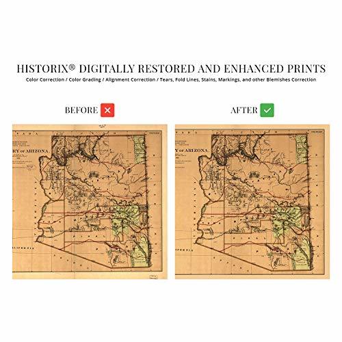
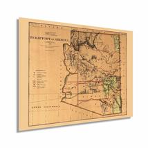
Published fourteen years after the region had been officially declared a territory, this depiction of Arizona shows the state in a period of relative growth as eager homesteaders arrived to establish vast cattle ranches and miners flocked to the region for the copper reserves which the state would eventually become famous for. Arizona’s remote landscape had kept the territory relatively untouched. Still, with Union Pacific completing the first transcontinental rail line in 1869, access had opened up access throughout much of the American Southwest.
While Arizona would not achieve statehood until 1912, it was critical for the United States to gain control of the region to establish a national boundary from the Atlantic to the Pacific ocean. The territory had been ceded to the United States from Mexico in the Treaty of Hidalgo in 1848, following their defeat in the Mexican-American War. Arizona had been a member of the Confederacy during the Civil War, but following a Confederate defeat at the Battle of Glorietta Pass in 1862, Confederate troops were forced to retreat to El Paso.
The landscape shifts from arid deserts in the southern portion of the state to the Rocky Mountains' southernmost reaches in the North. Produced by noted German-born lithographer Julien Bien, the unique aesthetic and distinctive style immediately transports the viewer back in time. Bien was one of the most prolific lithographers of the nineteenth century, and his works spanned three decades. This is a genuine piece of American cartographical history.
Our museum quality giclee print comes printed with archival ink on premium heavyweight matte paper. Shipped in a sturdy cardboard tube your print will arrive ready to be framed. This eye-catching vintage map reproduction print makes the perfect gift for anyone that loves history and imagery.
|
Why are we showing these items?
Booth
Historic Prints |

|


-
Refine your browsing experience
We can show you more items that are exactly like the original item, or we can show you items that are similar in spirit. By default we show you a mix.

This item has been added to your cart
 HISTORIX Vintage 1876 Arizona Territory Map - 18x24 Inch Vintage Arizona Map - O added to cart.
16 available in stock
HISTORIX Vintage 1876 Arizona Territory Map - 18x24 Inch Vintage Arizona Map - O added to cart.
16 available in stock
View Cart or continue shopping.
 Please wait while we finish adding this item to your cart.
Get an item reminder
We'll email you a link to your item now and follow up with a single reminder (if you'd like one). That's it! No spam, no hassle.
Already have an account?
Log in and add this item to your wish list.