HISTORIX Vintage 1889 Burlington Iowa Map and similar items


Free Shipping
HISTORIX Vintage 1889 Burlington Iowa Map Poster - Vintage Map of Burlington Cit
$39.99 - $59.99
View full item details »

Shipping options
Seller handling time is 1 business day Details
FREE via to United States
Return policy
Full refund available for DOAs
Details
Purchase protection
Payment options
PayPal accepted
PayPal Credit accepted
Venmo accepted
PayPal, MasterCard, Visa, Discover, and American Express accepted
Maestro accepted
Amazon Pay accepted
Nuvei accepted
View full item details »
Shipping options
Seller handling time is 1 business day Details
FREE via to United States
Return policy
Full refund available for DOAs
Details
Purchase protection
Payment options
PayPal accepted
PayPal Credit accepted
Venmo accepted
PayPal, MasterCard, Visa, Discover, and American Express accepted
Maestro accepted
Amazon Pay accepted
Nuvei accepted
Item traits
| Category: | |
|---|---|
| Quantity Available: |
16 in stock |
| Condition: |
New |
| ASIN: |
B0DTJNK39F |
| color: |
Natural |
| manufacturer: |
HISTORIX |
| Bullet Point: | |
| theme: |
Historical |
| Product Description: | |
| brand: |
HISTORIX |
| orientation: |
Landscape |
| Item Name: | |
| Item Type Keyword: |
prints |
| Wall Art Form: |
poster |
| sizes: |
Listing details
| Seller policies: | |
|---|---|
| Shipping discount: |
Seller pays shipping for this item. |
| Posted for sale: |
May 1 |
| Item number: |
1743606026 |
Item description
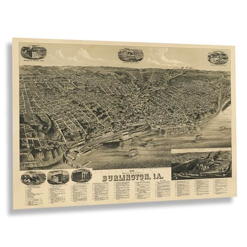
Following the Louisiana Purchase, President Thomas Jefferson organized two expeditions to explore the newly acquired territory. The Lewis Clark Expedition charted the Missouri River, while Lt. Zebulon Pike was tasked with following the Mississippi River. Pike’s journey led him to a site just south of what is now Burlington, Iowa, where he planted an American flag on what he described as the first U.S. soil in Iowa. Although Pike recommended the construction of a fort on this location, the idea never came to fruition. In its early years, the region was primarily inhabited by fur trappers, with a port established in 1829 and official settlements beginning in 1833.
By the time this panoramic map was created, Burlington had become a key steamboat hub and a critical connection along the Chicago, Burlington, and Quincy Railroad, a route that remains operational today as part of the BNSF Railway. This bird’s-eye perspective map was illustrated by Henry Wells, one of the most prolific cartographers of the 19th century, who, alongside four others, was responsible for more than half of the panoramic maps now in the Library of Congress’s permanent collection.
Bird’s-eye perspective maps, popular in the 19th century, were designed to promote cities and entice new residents. These maps often highlighted prominent civic landmarks and features, prioritizing visual appeal over navigational accuracy. As a result, they bear a distinctive aesthetic and unique style that is both immediately recognizable and evocative of a transformative period in American history.
Additional Details
------------------------------
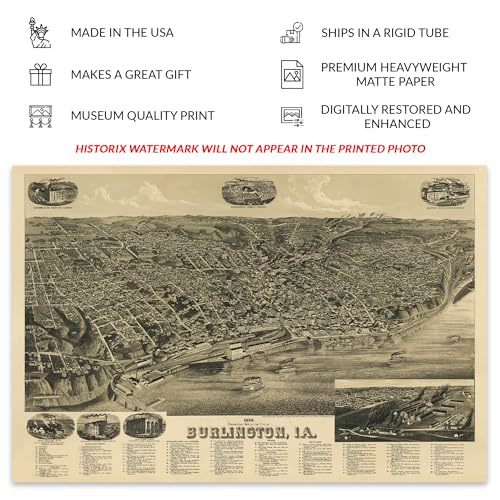
Bullet point: VINTAGE MAP REPRODUCTION: You?ll love this high quality historic reproduction of 1889 Burlington Iowa Map Poster. Our museum quality prints are archival grade, which means it will look great and last without fading for over 100 years. Our print to order maps are made in the USA and each map is inspected for quality. This beautiful artwork is a perfect addition to your themed decor. Vintage maps look great in the home, study or office. They make a perfect gift as well.
Product description:
Following the Louisiana Purchase, President Thomas Jefferson organized two expeditions to explore the newly acquired territory. The Lewis Clark Expedition charted the Missouri River, while Lt. Zebulon Pike was tasked with following the Mississippi River. Pike’s journey led him to a site just south of what is now Burlington, Iowa, where he planted an American flag on what he described as the first U.S. soil in Iowa. Although Pike recommended the construction of a fort on this location, the idea never came to fruition. In its early years, the region was primarily inhabited by fur trappers, with a port established in 1829 and official settlements beginning in 1833.
By the time this panoramic map was created, Burlington had become a key steamboat hub and a critical connection along the Chicago, Burlington, and Quincy Railroad, a route that remains operational today as part of the BNSF Railway. This bird’s-eye perspective map was illustrated by Henry Wells, one of the most prolific cartographers of the 19th century, who, alongside four others, was responsible for more than half of the panoramic maps now in the Library of Congress’s permanent collection.
Bird’s-eye perspective maps, popular in the 19th century, were designed to promote cities and entice new residents. These maps often highlighted prominent civic landmarks and features, prioritizing visual appeal over navigational accuracy. As a result, they bear a distinctive aesthetic and unique style that is both immediately recognizable and evocative of a transformative period in American history.
Loading
This item has been added to your cart
 HISTORIX Vintage 1889 Burlington Iowa Map Poster - Vintage Map of Burlington Cit added to cart.
16 available in stock
HISTORIX Vintage 1889 Burlington Iowa Map Poster - Vintage Map of Burlington Cit added to cart.
16 available in stock
View Cart or continue shopping.
 Please wait while we finish adding this item to your cart.
Get an item reminder
We'll email you a link to your item now and follow up with a single reminder (if you'd like one). That's it! No spam, no hassle.
Already have an account?
Log in and add this item to your wish list.