HISTORIX Vintage 1876 Map of Oregon Canvas - and 50 similar items


Free Shipping
HISTORIX Vintage 1876 Map of Oregon Canvas - 16x24x1.5 Inch Canvas Wrap Vintage
$251.99 - $280.99
View full item details »

Shipping options
Seller handling time is 1 business day Details
FREE via to United States
Return policy
Full refund available for DOAs
Details
Purchase protection
Payment options
PayPal accepted
PayPal Credit accepted
Venmo accepted
PayPal, MasterCard, Visa, Discover, and American Express accepted
Maestro accepted
Amazon Pay accepted
Nuvei accepted
View full item details »
Shipping options
Seller handling time is 1 business day Details
FREE via to United States
Return policy
Full refund available for DOAs
Details
Purchase protection
Payment options
PayPal accepted
PayPal Credit accepted
Venmo accepted
PayPal, MasterCard, Visa, Discover, and American Express accepted
Maestro accepted
Amazon Pay accepted
Nuvei accepted
Item traits
| Category: | |
|---|---|
| Quantity Available: |
16 in stock |
| Condition: |
New |
| ASIN: |
B098MX5ZPH |
| Item Name: |
1876 Oregon State |
| Item Type Keyword: |
artwork |
| Product Site Launch Date: |
2021-07-04T21:20:25.125Z |
| Unspsc Code: |
44103112 |
| sizes: |
Listing details
| Seller policies: | |
|---|---|
| Shipping discount: |
Seller pays shipping for this item. |
| Posted for sale: |
May 1 |
| Item number: |
1743598057 |
Item description
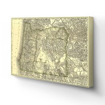
Published in 1876 by arguably the most prolific and recognizable mapmaker Rand McNally, this depiction of Oregon illustrates the vital links the railways provided as centralizing and dispersement tools. By this time, Oregon’s robust rail system allowed Portland to thrive. The City was experiencing a time of great prosperity, and the accessibility of raw materials made investors clamor to build. Portland was home to nearly twenty-thousand residents near the close of the decade.
Following the economic boom caused by the Oregon Gold Rush in the 1850s, the state was now primarily supported by the robust lumber industry. The ability to transport large timber from the region via the Willamette River allowed mills in Portland to process it into lumber, and the railroads would take it east to the heart of the country. This flourishing economy led to Portland’s enduring nickname “Stumptown.”
While the rest of the state remained mostly agrarian, Portland had become a contemporary city and was rivaled only by San Francisco to the South. The City had suffered from a significant fire in 1873 that destroyed much of the downtown area. The fire resulted in a change to the building codes creating many steel structures that have come to define the distinct aesthetic of the City.
Oregon found itself on the edge of modernity but still a rough and tumble western frontier in the 1870s. This distinctive map immediately transports the viewer back in time and is truly an authentic piece of cartographical history.
Our ready-to-hang canvas wall art prints are made in the USA using the highest quality materials with professional craftsmanship. This beautiful artwork is a perfect addition to your themed decor. Historic prints look great in the home, study or office. They also make an unforgettable gift.
|
Why are we showing these items?
Booth
Historic Prints |

|


-
Refine your browsing experience
We can show you more items that are exactly like the original item, or we can show you items that are similar in spirit. By default we show you a mix.


This item has been added to your cart
 HISTORIX Vintage 1876 Map of Oregon Canvas - 16x24x1.5 Inch Canvas Wrap Vintage added to cart.
16 available in stock
HISTORIX Vintage 1876 Map of Oregon Canvas - 16x24x1.5 Inch Canvas Wrap Vintage added to cart.
16 available in stock
View Cart or continue shopping.
 Please wait while we finish adding this item to your cart.
Get an item reminder
We'll email you a link to your item now and follow up with a single reminder (if you'd like one). That's it! No spam, no hassle.
Already have an account?
Log in and add this item to your wish list.