HISTORIX 1881 Oahu Hawaii Vintage Map - and 50 similar items


Free Shipping
HISTORIX 1881 Oahu Hawaii Vintage Map - 18x24 Inch Vintage Map of Oahu Hawaii Wa
$39.99 - $59.99
View full item details »

Shipping options
Seller handling time is 1 business day Details
FREE via to United States
Return policy
Full refund available for DOAs
Details
Purchase protection
Payment options
PayPal accepted
PayPal Credit accepted
Venmo accepted
PayPal, MasterCard, Visa, Discover, and American Express accepted
Maestro accepted
Amazon Pay accepted
Nuvei accepted
View full item details »
Shipping options
Seller handling time is 1 business day Details
FREE via to United States
Return policy
Full refund available for DOAs
Details
Purchase protection
Payment options
PayPal accepted
PayPal Credit accepted
Venmo accepted
PayPal, MasterCard, Visa, Discover, and American Express accepted
Maestro accepted
Amazon Pay accepted
Nuvei accepted
Item traits
| Category: | |
|---|---|
| Quantity Available: |
16 in stock |
| Condition: |
New |
| ASIN: |
B0893JPJXN |
| Item Name: |
HISTORIX 1881 Oahu, Hawaiian Islands |
| manufacturer: |
Historix |
| Item Type Keyword: |
prints |
| Product Site Launch Date: |
2020-05-23T18:15:22.120Z |
| Brand: |
HISTORIX |
| Unspsc Code: |
60121013 |
| sizes: |
Listing details
| Seller policies: | |
|---|---|
| Shipping discount: |
Seller pays shipping for this item. |
| Posted for sale: |
May 1 |
| Item number: |
1743597151 |
Item description
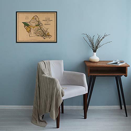
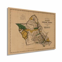
Illustrated by prominent American cartographer Richard Covington, this depiction of Hawaii shows the delineation of Royal and Government lands with Crown lands shown in yellow. Hawaii was still a kingdom in 1881 and would not be annexed as a United States territory until 1898. Covington’s unique aesthetic and technical skill show the island of Oahu in a time before significant periods of immigration and industrial farming would transform the culture and identity of the island.
This era in Hawaii’s rich history saw a transition from a primarily subsistence farming local community to agricultural stakes from Europe and the United States establishing large farms. These farms would produce much of the world’s sugar cane, and pineapples also became a huge economic driver for the islands.
This map was published only a century after the archipelago had been discovered by Captain James Cook, and set off the influx of explorers and traders who used the island as an outpost in the vastness of the Pacific Ocean. Sailing vessels from around the globe started arriving, and the islands became a diverse waypoint between North America and Southeast Asia as well as Japan.
The 1880s were also a period of revolution on the islands with the Rebellion of 1887 sparking a slew of tumultuous clashes until the final Rebellion of 1895 and the ultimate annexation by the United States at the close of the century. This unique piece of cartographical history exemplifies the remoteness of Hawaii and the iconic images that have come to be so familiar.
Our museum quality giclee print comes printed with archival ink on premium heavyweight matte paper. Shipped in a sturdy cardboard tube your print will arrive ready to be framed. This eye-catching vintage map reproduction print makes the perfect gift for anyone that loves history and imagery.
|
Why are we showing these items?
Booth
Historic Prints |

|


-
Refine your browsing experience
We can show you more items that are exactly like the original item, or we can show you items that are similar in spirit. By default we show you a mix.


This item has been added to your cart
 HISTORIX 1881 Oahu Hawaii Vintage Map - 18x24 Inch Vintage Map of Oahu Hawaii Wa added to cart.
16 available in stock
HISTORIX 1881 Oahu Hawaii Vintage Map - 18x24 Inch Vintage Map of Oahu Hawaii Wa added to cart.
16 available in stock
View Cart or continue shopping.
 Please wait while we finish adding this item to your cart.
Get an item reminder
We'll email you a link to your item now and follow up with a single reminder (if you'd like one). That's it! No spam, no hassle.
Already have an account?
Log in and add this item to your wish list.