HISTORIX Vintage 1880 Fort Worth Map Print - and 50 similar items


Free Shipping
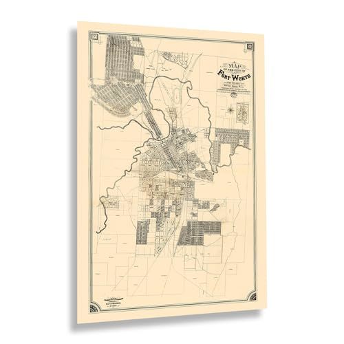
HISTORIX Vintage 1880 Fort Worth Map Print - 24x36 Inch Vintage Map of Fort Wort
$59.99
View full item details »

Shipping options
Seller handling time is 1 business day Details
FREE via to United States
Return policy
Full refund available for DOAs
Details
Purchase protection
Payment options
PayPal accepted
PayPal Credit accepted
Venmo accepted
PayPal, MasterCard, Visa, Discover, and American Express accepted
Maestro accepted
Amazon Pay accepted
Nuvei accepted
View full item details »
Shipping options
Seller handling time is 1 business day Details
FREE via to United States
Return policy
Full refund available for DOAs
Details
Purchase protection
Payment options
PayPal accepted
PayPal Credit accepted
Venmo accepted
PayPal, MasterCard, Visa, Discover, and American Express accepted
Maestro accepted
Amazon Pay accepted
Nuvei accepted
Item traits
| Category: | |
|---|---|
| Quantity Available: |
8 in stock |
| Condition: |
New |
| UPC: |
705514890399 |
| MPN: |
ENMAP06812436 |
| EAN: |
0705514890399 |
| Color: |
Natural |
| binding: |
unbound |
| format: |
unbound |
| language: |
english |
| manufacturer: |
HISTORIX |
| Externally Assigned Product Identifier: |
0705514890399 |
| Bullet Point: | |
| Publication Date: |
1880T |
| Product Description: | |
| Brand: |
HISTORIX |
| Unspsc Code: |
55101500 |
| Paper Finish: |
matte |
| Map Scale: |
1000 |
| Item Name: | |
| Item Type Keyword: |
prints |
| Product Site Launch Date: |
2023-11-15T02:50:48.206Z |
| Part Number: |
ENMAP06812436 |
Listing details
| Seller policies: | |
|---|---|
| Shipping discount: |
Seller pays shipping for this item. |
| Posted for sale: |
April 3 |
| Item number: |
1735833275 |
Item description
Home to the iconic stockyards and a hub for cattle ranching and trading, Fort Worth, Texas, has a long history that started when an Army outpost was established in the area in 1849. This outpost was installed as a series of Army bases designed to protect settlers in the Republic of Texas following the conclusion of the Mexican War. By the time of this map's production, the region had expanded considerably as demand for cattle grew across the United States following the conclusion of the American Civil War. Fort Worth remains one of the most iconic Texas cities and was pivotal in creating the lore of the American West, especially during the latter portions of the nineteenth century.
Cattle ranching was the largest industry in Texas in the nineteenth century. Fort Worth became the central hub for trading and selling cattle as a stop on the legendary Chisholm Trail, which saw millions of head of cattle travel head through the city annually. The city suffered during the Civil War, and the population dropped to as low as one hundred and seventy-five residents. However, the period during reconstruction saw Fort Worth make a rapid recovery, and it is now Texas' fifth largest city.
This map bears a classic, minimal style that immediately transports the viewer back in time, creating an indelible bond between the past and present. Fort Worth's distinctive culture and history attract thousands of tourists each year for the museums, historic stockyards, and its classic Texas history.
Additional Details
------------------------------
Bullet point: VINTAGE MAP REPRODUCTION: You?ll love this high quality historic reproduction of 1880 Fort Worth Map Print. Our museum quality prints are archival grade, which means it will look great and last without fading for over 100 years. Our print to order maps are made in the USA and each map is inspected for quality. This beautiful artwork is a perfect addition to your themed decor. Vintage maps look great in the home, study or office. They make a perfect gift as well.
Product description:
Home to the iconic stockyards and a hub for cattle ranching and trading, Fort Worth, Texas, has a long history that started when an Army outpost was established in the area in 1849. This outpost was installed as a series of Army bases designed to protect settlers in the Republic of Texas following the conclusion of the Mexican War. By the time of this map's production, the region had expanded considerably as demand for cattle grew across the United States following the conclusion of the American Civil War. Fort Worth remains one of the most iconic Texas cities and was pivotal in creating the lore of the American West, especially during the latter portions of the nineteenth century.
Cattle ranching was the largest industry in Texas in the nineteenth century. Fort Worth became the central hub for trading and selling cattle as a stop on the legendary Chisholm Trail, which saw millions of head of cattle travel head through the city annually. The city suffered during the Civil War, and the population dropped to as low as one hundred and seventy-five residents. However, the period during reconstruction saw Fort Worth make a rapid recovery, and it is now Texas' fifth largest city.
This map bears a classic, minimal style that immediately transports the viewer back in time, creating an indelible bond between the past and present. Fort Worth's distinctive culture and history attract thousands of tourists each year for the museums, historic stockyards, and its classic Texas history.
Format: wall_map
|
Why are we showing these items?
Booth
Historic Prints |

|


-
Refine your browsing experience
We can show you more items that are exactly like the original item, or we can show you items that are similar in spirit. By default we show you a mix.


This item has been added to your cart
 HISTORIX Vintage 1880 Fort Worth Map Print - 24x36 Inch Vintage Map of Fort Wort added to cart.
8 available in stock
HISTORIX Vintage 1880 Fort Worth Map Print - 24x36 Inch Vintage Map of Fort Wort added to cart.
8 available in stock
View Cart or continue shopping.
 Please wait while we finish adding this item to your cart.
Get an item reminder
We'll email you a link to your item now and follow up with a single reminder (if you'd like one). That's it! No spam, no hassle.
Already have an account?
Log in and add this item to your wish list.