HISTORIX Vintage 1652 North America Map and 50 similar items


Free Shipping
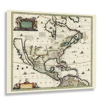
HISTORIX Vintage 1652 North America Map Poster - 24x30 Inch Old Map Print of Ame
$54.99
View full item details »

Shipping options
Seller handling time is 1 business day Details
FREE via to United States
Return policy
Full refund available for DOAs
Details
Purchase protection
Payment options
PayPal accepted
PayPal Credit accepted
Venmo accepted
PayPal, MasterCard, Visa, Discover, and American Express accepted
Maestro accepted
Amazon Pay accepted
Nuvei accepted
View full item details »
Shipping options
Seller handling time is 1 business day Details
FREE via to United States
Return policy
Full refund available for DOAs
Details
Purchase protection
Payment options
PayPal accepted
PayPal Credit accepted
Venmo accepted
PayPal, MasterCard, Visa, Discover, and American Express accepted
Maestro accepted
Amazon Pay accepted
Nuvei accepted
Item traits
| Category: | |
|---|---|
| Quantity Available: |
8 in stock |
| Condition: |
New |
| MPN: |
ENMAP06762430 |
| UPC: |
705514890290 |
| EAN: |
0705514890290 |
| color: |
Natural |
| binding: |
unbound |
| format: |
unbound |
| language: |
english |
| manufacturer: |
HISTORIX |
| Externally Assigned Product Identifier: |
0705514890290 |
| Bullet Point: | |
| Publication Date: |
1652T |
| Product Description: | |
| Brand: |
HISTORIX |
| Unspsc Code: |
55101500 |
| Paper Finish: |
matte |
| Map Scale: |
1000 |
| Item Name: | |
| Item Type Keyword: |
wall-maps |
| Product Site Launch Date: |
2023-11-04T08:09:35.867Z |
| Part Number: |
ENMAP06762430 |
Listing details
| Seller policies: | |
|---|---|
| Shipping discount: |
Seller pays shipping for this item. |
| Posted for sale: |
More than a week ago |
| Item number: |
1735778222 |
Item description
Produced by the Dutch cartographer Jan Jansson, this depiction of North America in 1652 remains an early representation of the continent in its first stages of colonization as settlers from across Western Europe began to build communities as immigration began to expand in what would eventually become the United States, Canada, and Mexico. This map shows the evolution of cartographic techniques. It is a prime example of a seventeenth-centurymethod and style that immediately transports the viewer back in time, creating an indelible bond between the past and present. This map was produced during the Age of Discovery when European settlers explored new lands and built colonies across the globe, especially in North America.
North America was largely colonized by Western Europeans, which led to the expansion of the English, French, and Spanish-speaking cultures that commingled with indigenous people and resulted in the communities and cultures that are reflected today. This map bears a distinctive aesthetic and unique style that immediately transports the viewer back in time, creating an indelible link to the present and the past that illustrates the evolution of cartographical techniques and the cultural landscape across North America.
The Americas were named after Italian explorer and cartographer Amerigo Vespucci by German mapmakers Martin Waldseemüller and Matthias Ringmann following Vespucci's expeditions to the continent between 1497 and 1502. This is an authentic piece of cartographical history by one of the most notable creators of the seventeenth century and remains an enduring image of the continent.
Additional Details
------------------------------
Bullet point: VINTAGE MAP REPRODUCTION: You?ll love this high quality historic reproduction of 1652 North America Wall Map Poster. Our museum quality prints are archival grade, which means it will look great and last without fading for over 100 years. Our print to order maps are made in the USA and each map is inspected for quality. This beautiful artwork is a perfect addition to your themed decor. Vintage maps look great in the home, study or office. They make a perfect gift as well.
Product description:
Produced by the Dutch cartographer Jan Jansson, this depiction of North America in 1652 remains an early representation of the continent in its first stages of colonization as settlers from across Western Europe began to build communities as immigration began to expand in what would eventually become the United States, Canada, and Mexico. This map shows the evolution of cartographic techniques. It is a prime example of a seventeenth-centurymethod and style that immediately transports the viewer back in time, creating an indelible bond between the past and present. This map was produced during the Age of Discovery when European settlers explored new lands and built colonies across the globe, especially in North America.
North America was largely colonized by Western Europeans, which led to the expansion of the English, French, and Spanish-speaking cultures that commingled with indigenous people and resulted in the communities and cultures that are reflected today. This map bears a distinctive aesthetic and unique style that immediately transports the viewer back in time, creating an indelible link to the present and the past that illustrates the evolution of cartographical techniques and the cultural landscape across North America.
The Americas were named after Italian explorer and cartographer Amerigo Vespucci by German mapmakers Martin Waldseemüller and Matthias Ringmann following Vespucci's expeditions to the continent between 1497 and 1502. This is an authentic piece of cartographical history by one of the most notable creators of the seventeenth century and remains an enduring image of the continent.
Format: wall_map
|
Why are we showing these items?
Booth
Historic Prints |

|


-
Refine your browsing experience
We can show you more items that are exactly like the original item, or we can show you items that are similar in spirit. By default we show you a mix.

This item has been added to your cart
 HISTORIX Vintage 1652 North America Map Poster - 24x30 Inch Old Map Print of Ame added to cart.
8 available in stock
HISTORIX Vintage 1652 North America Map Poster - 24x30 Inch Old Map Print of Ame added to cart.
8 available in stock
View Cart or continue shopping.
 Please wait while we finish adding this item to your cart.
Get an item reminder
We'll email you a link to your item now and follow up with a single reminder (if you'd like one). That's it! No spam, no hassle.
Already have an account?
Log in and add this item to your wish list.