Proseries Wall Map: Northern Virginia / and similar items
Free Shipping
PROSERIES WALL MAP: NORTHERN VIRGINIA / WASHINGTON D.C. (R)
$266.31
Sign up and get $15.00 bCredits free to use at checkout and another $5.00 bCredits when you make your first purchase. More info
Share & earn! Sign in, share this or any listing, and you’ll get commission when it sells.
Learn more
View full item details »

Shipping options
Estimated to arrive by Thu, Nov 20th.
Details
FREE via UPS Ground (1 to 5 business days) to United States
Return policy
Replacement product available within 30 days
Details
Purchase protection
Payment options
PayPal accepted
PayPal Credit accepted
Venmo accepted
PayPal, MasterCard, Visa, Discover, and American Express accepted
Maestro accepted
Amazon Pay accepted
Nuvei accepted
View full item details »
Shipping options
Estimated to arrive by Thu, Nov 20th.
Details
FREE via UPS Ground (1 to 5 business days) to United States
Return policy
Replacement product available within 30 days
Details
Purchase protection
Payment options
PayPal accepted
PayPal Credit accepted
Venmo accepted
PayPal, MasterCard, Visa, Discover, and American Express accepted
Maestro accepted
Amazon Pay accepted
Nuvei accepted
Item traits
| Category: | |
|---|---|
| Quantity Available: |
Only one in stock, order soon |
| Condition: |
New |
| Country/Region of Manufacture: |
United States |
Listing details
| Seller policies: | |
|---|---|
| Posted for sale: |
More than a week ago |
| Item number: |
738129287 |
Item description
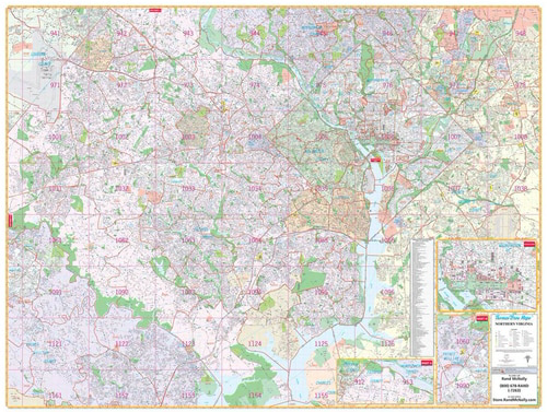
PROSERIES WALL MAP: NORTHERN VIRGINIA / WASHINGTON D.C. (R)
DESCRIPTION
Rand McNally's wall map of Northern Virginia/Washington, D.C. is ideal for anyone needing a comprehensive representation of the region for planning, routing, or reference. It's a great choice for business and sales strategy, urban development, social work outreach, education, and marketing.
D.C.-area residents, businesses, and government offices are sure to find this wonderful reference tool irreplaceable.
Note: This map is not available for gift wrapping. Please allow 7-10 days for shipping.
Laminated wall map printed with UV-resistant ink to help prevent color fading
Map details include airports, hospitals, railroads, points of interest, shopping centers, parks, golf and country clubs, post offices, police and fire stations, schools and educational institutions, government buildings, mileage circles, block numbers, city limits and annexations, ZIP codes and boundaries, and much more
Includes a separate street index book
Hanging kit with rails for easy mounting
COVERAGE AREA
Coverage area extends:
North to the Fairfax/Montgomery County line
South to Mason Neck State Park
East to the Capital Beltway, including New Carrolton and Glenarden
West to Manassas and Manassas Park in Prince Williams County, includes
PRODUCT DETAILS
Dimensions: 79" x 60"; Scale: (in feet): 1:2,506. Copyright 2004.
Loading
This item has been added to your cart
 PROSERIES WALL MAP: NORTHERN VIRGINIA / WASHINGTON D.C. (R) added to cart.
Only one available in stock
PROSERIES WALL MAP: NORTHERN VIRGINIA / WASHINGTON D.C. (R) added to cart.
Only one available in stock
View Cart or continue shopping.
 Please wait while we finish adding this item to your cart.
Get an item reminder
We'll email you a link to your item now and follow up with a single reminder (if you'd like one). That's it! No spam, no hassle.
Already have an account?
Log in and add this item to your wish list.