Unique highway map showing the current and and 50 similar items

Free Shipping
98 recent views
Unique highway map showing the current and historic system of U.S. routes
$60.00 - $150.00
(It may be possible to pay only $57.00 instead of $60.00 when you
use your bCredits at checkout)
Sign up and get $5.00 bCredits free to use at checkout and another $5.00 bCredits when you make your first purchase. More info
Share & earn! Sign in, share this or any listing, and you’ll get commission when it sells.
Learn more
View full item details »

Shipping options
Estimated to arrive by Tue, Jul 21st.
Details
FREE via UPS Ground (1 to 5 business days) to United States
Return policy
None: All purchases final
Purchase protection
Payment options
PayPal accepted
PayPal Credit accepted
Venmo accepted
PayPal, MasterCard, Visa, Discover, and American Express accepted
Maestro accepted
Amazon Pay accepted
Nuvei accepted
View full item details »
Shipping options
Estimated to arrive by Tue, Jul 21st.
Details
FREE via UPS Ground (1 to 5 business days) to United States
Return policy
None: All purchases final
Purchase protection
Payment options
PayPal accepted
PayPal Credit accepted
Venmo accepted
PayPal, MasterCard, Visa, Discover, and American Express accepted
Maestro accepted
Amazon Pay accepted
Nuvei accepted
Item traits
| Category: | |
|---|---|
| Quantity Available: |
37 in stock |
| Condition: |
New |
| Country/Region of Manufacture: |
United States |
| Handmade: |
No |
| Listed By: |
Artist |
| Materials: | |
| Sizes: |
Listing details
| Shipping discount: |
Seller pays shipping for this item. |
|---|---|
| Posted for sale: |
More than a week ago |
| Item number: |
549997508 |
Item description
What is unique about this map?
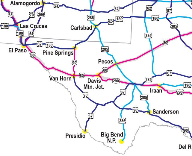
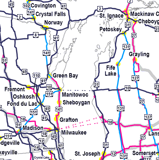
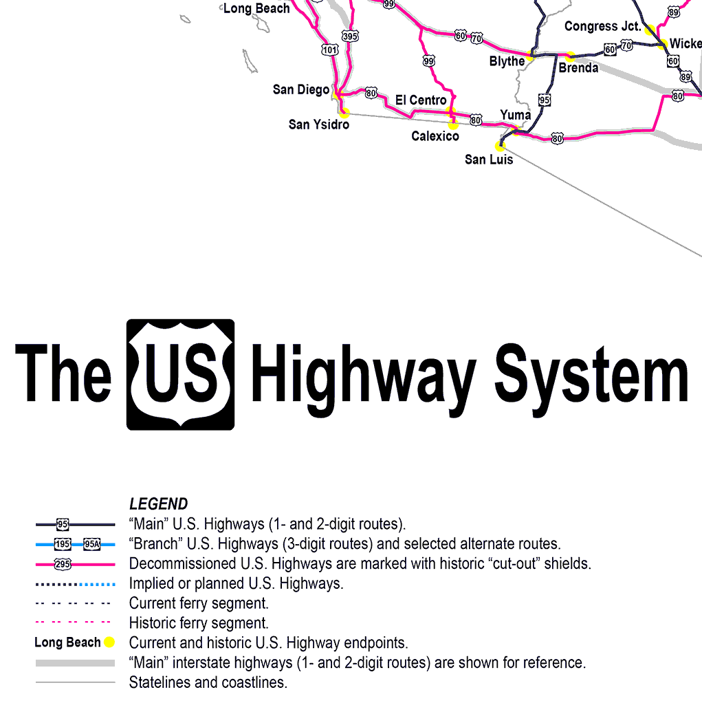
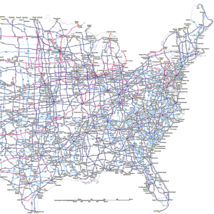
Most maps portray a snapshot in time. For example, a highway map published in 1956 would have illustrated the route network as it existed at that time, but it would not have included any of the highways that were decommissioned prior to 1956, nor any of the future highways that would be commissioned after 1956. What makes this map unique is: rather than portraying a snapshot in time, it shows on a single map all of the US routes that have ever existed (regardless of when they existed).
All of the US routes that were commissioned in 1926 (whether they still exist or not).
All of the US routes that have been decommissioned since 1926, from the earliest (US 102 in 1928) to the most recent (US 666 in 2003).
All of the US routes that were commissioned after 1926, from the earliest (US 401, 164, and 422 in 1927) to the most recent (US 121 in 2005).
All of the US route extensions and truncations that have taken place since 1926, from the earliest in 1927 to the latest (US 78 in 2023).
More details
This map, then, shows the entire system of US routes* and is continually revised and updated. One- and two-digit main routes (or "parent" routes) are depicted with purple lines; three-digit branch routes (or "child" routes) are shown in blue; decommissioned routes are red. Locations of current and historic endpoints are labeled. Hover over the images above to see examples.
*Note: US highways are not the same as Interstate highways. The focus of this map is the US route system, which was originally commissioned in 1926, and which predates the Interstate highway system by about 30 years. Main Interstate routes are also shown on this map, but inconspicuously and only for reference, and they are not labeled.
The map was originally designed for the 3' x 4' configuration, and the labels are more legible at that size. If the map will be displayed on a wall, the 3' x 4' size is the best option in most cases. At the 2' x 3' size, the labels are still legible, but one needs to be closer to the map in order to read it. The smaller size makes the 2' x 3' map easier to transport.
If you order a map printed on paper, it will arrive rolled up in a cardboard tube in order to avoid creases (allow time to flatten). Or you can choose to have your map mounted on foam core board and delivered flat. To order a foamcore map, choose "Other" in the pop-up menu.
Prices shown here are valid for U.S. customers only. Shipped via UPS or FedEx, maps usually reach almost any U.S. address in about a week.
Any questions?
Outside the United States?
Interested in a customized version of this map (e.g. different size, different paper stock, lamination, different color scheme, etc.)?
Please contact the seller.
Reviews
From 2018-2025 we sold our map through a different platform. Prior to leaving that platform we saved screenshots of the customer reviews, which you can read here. -- It may be necessary to copy that link and paste into a new tab.
|
Why are we showing these items?
Search Results
Category "US"
|


 - $3.70")
 - $3.90")


-
Refine your browsing experience
We can show you more items that are exactly like the original item, or we can show you items that are similar in spirit. By default we show you a mix.


This item has been added to your cart
 Unique highway map showing the current and historic system of U.S. routes added to cart.
37 available in stock
Unique highway map showing the current and historic system of U.S. routes added to cart.
37 available in stock
View Cart or continue shopping.
 Please wait while we finish adding this item to your cart.
Get an item reminder
We'll email you a link to your item now and follow up with a single reminder (if you'd like one). That's it! No spam, no hassle.
Already have an account?
Log in and add this item to your wish list.