Bull's Bay Harbor of Refuge 1851 Sketch and 49 similar items
Bull's Bay Harbor of Refuge 1851 Sketch South Carolina US Coast Survey Map
$148.50
(Buy a Up to 15% discount card for $15.00 first, and you will save $16.34 on this item and get up to 15% off future purchases for the next 3 months.
Unlock the discount with just a few clicks - start here)
Share & earn! Sign in, share this or any listing, and you’ll get commission when it sells.
Learn more
View full item details »
Shipping options
$6.99 to United States
Offer policy
OBO - Seller accepts offers on this item.
Details
Return policy
Refunds available: See booth/item description for details
Purchase protection
Payment options
PayPal accepted
PayPal Credit accepted
Venmo accepted
PayPal, MasterCard, Visa, Discover, and American Express accepted
Maestro accepted
Amazon Pay accepted
Nuvei accepted
Item traits
| Category: | |
|---|---|
| Quantity Available: |
Only one in stock, order soon |
| Condition: |
Unspecified by seller, may be new. |
| Date Range: |
1800-1899 |
| Year: |
1851 |
| Country/Region: |
United States of America |
Listing details
| Posted for sale: |
March 10 |
|---|---|
| Item number: |
1797117033 |
Item description
Bull's Bay Harbor of Refuge 1851 Sketch South Carolina US Coast Survey Map
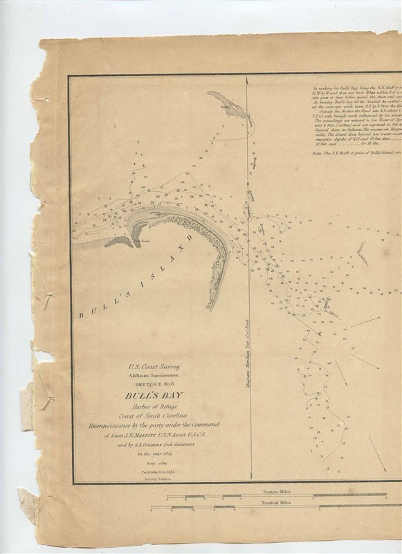
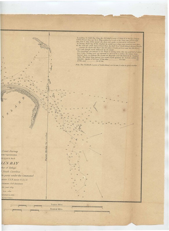
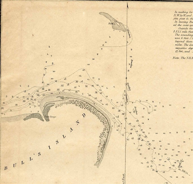
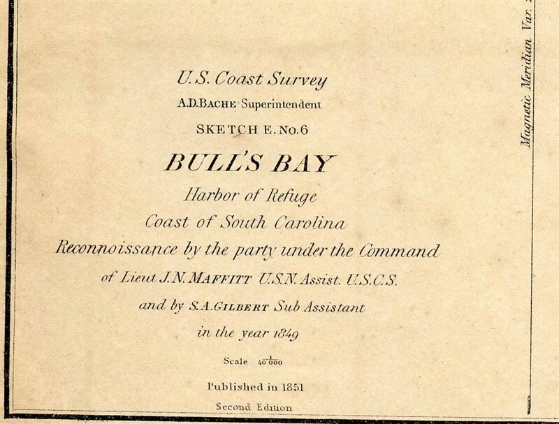
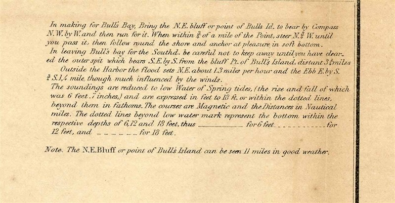
This is Sketch E No 6. Preliminary Sketch of Bull's Bay, Harbor of Refuge By The Hydrographic Party of the US Coast Survey Under the Command of J N Maffitt, LT US Navy. dated 1851. From the Sketches Accompanying the Annual Report of the Superintendent of the United States Coast Survey 1851. The map measures about 11 3/4 x 10 1/4" There is light wear of the formerly bound edge and a topt edge tear and chips. . A very nice original historical drawing, that would look great framed. In fine condition . With detailed Sailing directions and more. . Had been folded in the Annual Report Book.
in very good collectible condition with rough edge from removal from the Annual Report Book.
Our Policies:
For Multiple Purchases A single payment for all items would be appreciated.
We Ship World Wide Due to the Impact of USPS Policy Changes, Delivery time of some International Packages may be 8 to 18 weeks or more
International Buyers ? Please Note:
Import duties, taxes, and charges are not included in the item price or shipping cost. These charges are the buyer's responsibility.
Please check with your country's customs office to determine what these additional costs will be prior to bidding or buying.
STATE Sales Tax Based on Applicable Tax Laws, will calculate and, collect Sales Tax for items shipped to customers in States requiring Sales Tax collection.
You may be interested in our other listings.
Powered by SixBit's eCommerce Solution
|
Why are we showing these items?
Search Results
Map, maps, atlases & globes"map" Category "Maps, Atlases & Globes"
|


 - $4.90")


-
Refine your browsing experience
We can show you more items that are exactly like the original item, or we can show you items that are similar in spirit. By default we show you a mix.
This item has been added to your cart
 Bull's Bay Harbor of Refuge 1851 Sketch South Carolina US Coast Survey Map added to cart.
Only one available in stock
Bull's Bay Harbor of Refuge 1851 Sketch South Carolina US Coast Survey Map added to cart.
Only one available in stock
View Cart or continue shopping.
 Please wait while we finish adding this item to your cart.
Get an item reminder
We'll email you a link to your item now and follow up with a single reminder (if you'd like one). That's it! No spam, no hassle.
Already have an account?
Log in and add this item to your wish list.