HISTORIX Vintage 1856 Chester County and 50 similar items


Free Shipping
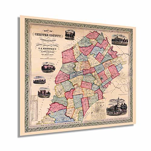
HISTORIX Vintage 1856 Chester County Pennsylvania Map - 20x24 Inch Chester Count
$45.99 - $54.99
View full item details »

Shipping options
Seller handling time is 1 business day Details
FREE via to United States
Return policy
Full refund available for DOAs
Details
Purchase protection
Payment options
PayPal accepted
PayPal Credit accepted
Venmo accepted
PayPal, MasterCard, Visa, Discover, and American Express accepted
Maestro accepted
Amazon Pay accepted
Nuvei accepted
View full item details »
Shipping options
Seller handling time is 1 business day Details
FREE via to United States
Return policy
Full refund available for DOAs
Details
Purchase protection
Payment options
PayPal accepted
PayPal Credit accepted
Venmo accepted
PayPal, MasterCard, Visa, Discover, and American Express accepted
Maestro accepted
Amazon Pay accepted
Nuvei accepted
Item traits
| Category: | |
|---|---|
| Quantity Available: |
16 in stock |
| Condition: |
New |
| ASIN: |
B08C4XLG64 |
| Item Name: |
HISTORIX 1856 Map of Chester County, Pennsylvania |
| manufacturer: |
HISTORIX |
| Item Type Keyword: |
prints |
| Product Site Launch Date: |
2020-07-01T03:02:41.331Z |
| Brand: |
HISTORIX |
| Unspsc Code: |
60121013 |
| sizes: |
Listing details
| Seller policies: | |
|---|---|
| Shipping discount: |
Seller pays shipping for this item. |
| Posted for sale: |
May 1 |
| Item number: |
1743604672 |
Item description
One of the first three counties founded by William Penn in 1682 Chester County played an essential role in the American Revolution and holds a rich history. The eastern portion of the county enjoyed a robust shipbuilding industry while the western regions thrived on the fertile soil, and agricultural production was the primary economic driver.
The Battle of Brandywine was fought in Chester County in 1777 as British General Sir William Howe marched east in an attempt to siege Philadelphia, which was the Continental capital during this time. More troops engaged in this battle than any other during the American Revolution, and it was also the longest conflict of the war with continuous fighting for over eleven hours. The Continental forces led by General George Washington mounted their fight from Brandywine Creek, but due to poor initial scouting were forced to retreat after the lengthy battle. General Nathaniel Greene’s troops held the British at bay while Washington’s troops found safety in the surrounding areas.
Published with great detail, this piece of cartographical and American History shows the county in a time of great prosperity, growth, and transition. As industrialization was spurring growth in the Northeast, manufacturing and textile production were common in this region, and immigrants were attracted to these areas due to widespread civil unrest in western Europe and famine in Ireland. Chester County was experiencing a boom in this era, and the unique aesthetic of this map immediately transports the viewer back in time.
Our museum quality giclee print comes printed with archival ink on premium heavyweight matte paper. Shipped in a sturdy cardboard tube your print will arrive ready to be framed. This eye-catching vintage map reproduction print makes the perfect gift for anyone that loves history and imagery.
|
Why are we showing these items?
Booth
Historic Prints |

|


-
Refine your browsing experience
We can show you more items that are exactly like the original item, or we can show you items that are similar in spirit. By default we show you a mix.


This item has been added to your cart
 HISTORIX Vintage 1856 Chester County Pennsylvania Map - 20x24 Inch Chester Count added to cart.
16 available in stock
HISTORIX Vintage 1856 Chester County Pennsylvania Map - 20x24 Inch Chester Count added to cart.
16 available in stock
View Cart or continue shopping.
 Please wait while we finish adding this item to your cart.
Get an item reminder
We'll email you a link to your item now and follow up with a single reminder (if you'd like one). That's it! No spam, no hassle.
Already have an account?
Log in and add this item to your wish list.