1879 Yamhill County Oregon Map - Old Yamhill and 50 similar items


Free Shipping
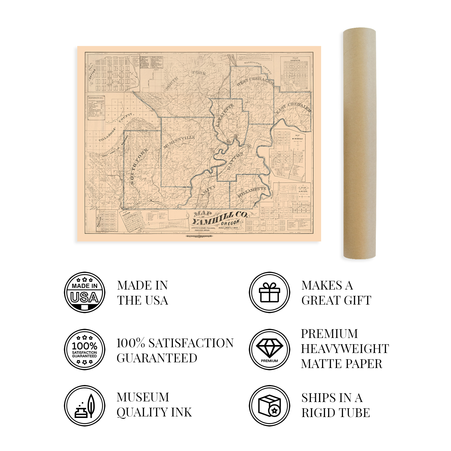
1879 Yamhill County Oregon Map - Old Yamhill County Map of OR Wall Art Poster
$59.99 - $82.99
View full item details »

Shipping options
Seller handling time is 1 business day Details
FREE in United States
Return policy
Full refund available for DOAs
Details
Purchase protection
Payment options
PayPal accepted
PayPal Credit accepted
Venmo accepted
PayPal, MasterCard, Visa, Discover, and American Express accepted
Maestro accepted
Amazon Pay accepted
Nuvei accepted
View full item details »
Shipping options
Seller handling time is 1 business day Details
FREE in United States
Return policy
Full refund available for DOAs
Details
Purchase protection
Payment options
PayPal accepted
PayPal Credit accepted
Venmo accepted
PayPal, MasterCard, Visa, Discover, and American Express accepted
Maestro accepted
Amazon Pay accepted
Nuvei accepted
Item traits
| Category: | |
|---|---|
| Quantity Available: |
16 in stock |
| Condition: |
New |
| Type: |
|
| Sizes: |
Listing details
| Seller policies: | |
|---|---|
| Shipping discount: |
Seller pays shipping for this item. |
| Posted for sale: |
April 13 |
| Item number: |
1738792572 |
Item description
Feature Points
VINTAGE MAP REPRODUCTION: You?ll love this high quality historic reproduction of 1879 Yamhill County Oregon Map Poster. Our museum quality prints are archival grade, which means it will look great and last without fading for over 100 years. Our print to order maps are made in the USA and each map is inspected for quality. This beautiful artwork is a perfect addition to your themed decor. Vintage maps look great in the home, study or office. They make a perfect gift as well.
MUSEUM QUALITY: This high quality map print will be a great addition to your vintage-themed wall. Don't waste money on cheap-looking, thin paper posters. We use thick, fine art print quality matte paper. Our professional?s choice matte paper displays artwork in high detail without glare. The color is vibrant and text is easy to read. When framed, this map looks absolutely stunning.
A LOOK BACK AT HISTORY: This is an impressive, historic reproduction of 1879 Map of Yamhill County Oregon Poster. A true piece of history. See our product description section for more fascinating information about this historic map and its significance.
READY TO FRAME: This print includes a 0.2 inch border for a perfect frame fit and look. Our maps are designed to fit easy-to-find standard frame sizes, saving you money from having to pay for a custom frame. Each map is inspected for quality and shipped in a rigid tube.
HISTORIX: We love history and art. Sometimes old maps have tears, folds, separations and other blemishes. We digitally restore and enhance maps while keeping its historical character. All our maps are proudly made in the USA. Customers all over the world love our vintage maps and we know you will too.
Additional Information
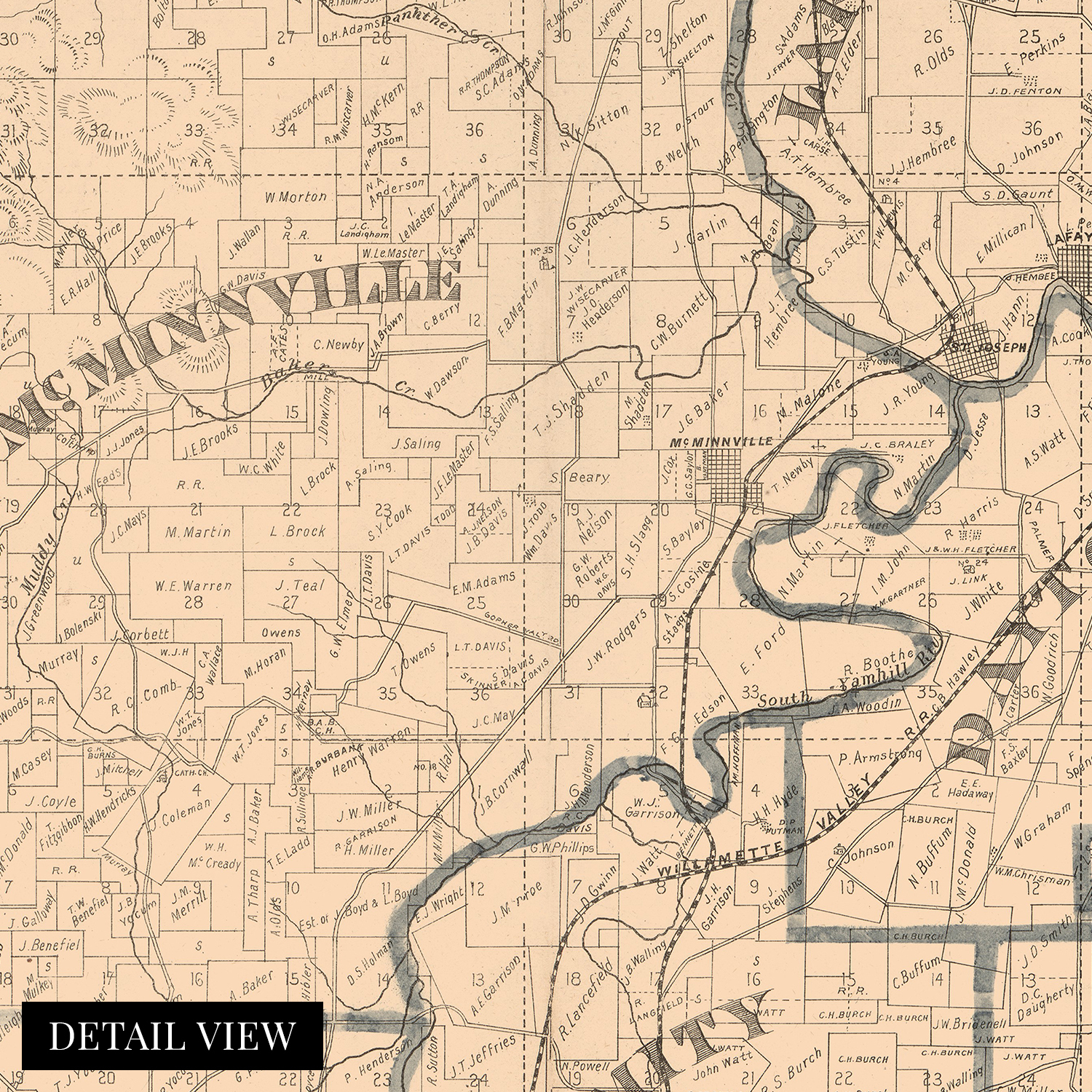
Located in the Willamette Valley and home to a major tributary of the Willamette River, Yamhill County has an enduring legacy and rich history that experienced significant transformation throughout the nineteenth century after the establishment of the Oregon Trail in 1811. The region would experience another significant population expansion following the completion of the transcontinental railroad and subsequent lines that opened up the Northwest. The Oregon Trail initially culminated at The Dalles to the East, but the completion of the Barlow Road in 1846 opened up settlement in the Willamette Valley. Yamhill County makes up the Southwestern portion of the Portland-Vancouver metropolitan area.
The county was established five years before the Oregon Territory and is one of the four original districts of the Provisional Legislature. Initially, the primary economic center of the county was Lafayette which was made county seat in 1847, though it moved one decade after this map?s publication to McMinnville, where it remains. The Yamhill River featured a lock and dam that was completed in 1900 but de-commissioned in 1954 to promote salmon passage through the region?s waterways. Throughout the nineteenth century, the area attracted immigrants from Great Britain and Europe who established numerous communities based along cultural lines, many of which exist to this day.
This is an authentic piece of American cartographical history that bears a distinctive style and classic aesthetic that immediately transports the viewer back in time, creating an indelible bond between the past and present while capturing the region?s rich history.
Our museum quality giclee print comes printed with archival ink on premium heavyweight matte paper. Shipped in a sturdy cardboard tube your print will arrive ready to be framed. This eye-catching vintage map reproduction print makes the perfect gift for anyone that loves history and imagery.


-
Refine your browsing experience
We can show you more items that are exactly like the original item, or we can show you items that are similar in spirit. By default we show you a mix.


This item has been added to your cart
 1879 Yamhill County Oregon Map - Old Yamhill County Map of OR Wall Art Poster added to cart.
16 available in stock
1879 Yamhill County Oregon Map - Old Yamhill County Map of OR Wall Art Poster added to cart.
16 available in stock
View Cart or continue shopping.
 Please wait while we finish adding this item to your cart.
Get an item reminder
We'll email you a link to your item now and follow up with a single reminder (if you'd like one). That's it! No spam, no hassle.
Already have an account?
Log in and add this item to your wish list.